
Nestled just outside San Francisco, Muir Woods National Monument lets you wander beneath ancient redwoods. There are about 6 miles of trails, so you can choose a short stroll or a longer hike if you’re feeling ambitious. Entrance is $15 per person, but it’s free for anyone 15 or younger.
Honestly, planning ahead makes or breaks your visit here. The monument is open daily from 8 am to sunset, year-round. If you’re coming in summer (June through August), get ready for crowds—this place gets packed with visitors.
Discover hand-picked hotels and vacation homes tailored for every traveler. Skip booking fees and secure your dream stay today with real-time availability!
Browse Accommodations Now
Pick a trail that fits your mood and schedule. There are loops that take 30 minutes, an hour, or up to 90 minutes. If you can, aim for a weekday or the off-season. Trust me, it’s way more peaceful with fewer people.

Overview of Muir Woods National Monument
Muir Woods National Monument is a protected sanctuary for ancient coastal redwoods just north of San Francisco. It’s like a living cathedral—some of the oldest and tallest trees on Earth, right there for you to see.
History and Establishment
President Theodore Roosevelt made Muir Woods a National Monument in 1908, naming it after naturalist John Muir, who championed the preservation of these forests.
William and Elizabeth Kent bought the land in 1905 to save the redwoods from logging. When water companies tried to claim the land, the Kents donated it to the federal government to keep it safe forever.

Logging had already wiped out many of Northern California’s redwood forests to build San Francisco. Muir Woods is one of the last old-growth redwood forests in the Bay Area, which makes it a real treasure.
Importance of Coastal Redwoods
The coastal redwoods (Sequoia sempervirens) in Muir Woods are some of the tallest living things anywhere. Many trees soar over 200 feet, with a few stretching up to 250 feet.
These giants are typically 400 to 800 years old, though redwoods can live for more than 2,000 years. Unlike the giant sequoias found inland, coastal redwoods thrive in the foggy climate along the Pacific.

Redwoods shape their own ecosystem. Their bark resists fire, and the forest floor beneath them supports unique plants and animals that depend on the shade and moisture these trees provide.
These redwoods also help fight climate change by storing huge amounts of carbon in their trunks and branches.
Location and How to Get There
Muir Woods sits in Marin County, about 16 miles north of San Francisco. The cool, foggy valley there creates the perfect environment for these trees.
You can drive, but you’ll need a parking reservation—space is tight. The road winds through some pretty stunning coastal scenery and thick forests.

There’s also the Muir Woods Shuttle, running weekends and holidays from Sausalito and other Marin County spots. It’s easier and greener than driving.
Since it’s so close to San Francisco, Muir Woods makes a popular day trip. Figure on at least 45 minutes to get there from the city, but leave extra time for traffic—especially in summer or on weekends.
Planning Your Visit
A good trip to Muir Woods takes some prep. With the park’s popularity, you’ll need to get the hang of reservations, timing, and how accessible things are if you want to enjoy yourself.
See available accommodations near Muir Woods
Best Time to Visit
If you want peace and quiet, go on a weekday morning. That’s when you’ll find fewer people and more parking. Summer and weekends are the busiest—tourists love the redwoods, too.
Early spring (March-April) brings bright green growth and running creeks, while fall is usually mild and less crowded. Winter can be really tranquil with misty weather, but expect some muddy trails.

Photographers—morning light through the redwoods is magic. The trees keep things cool in summer and fairly mild in winter, so it’s comfortable year-round.
Fog rolls in a lot during summer mornings, but it usually clears by afternoon.
See available accommodations near Muir Woods
Hours and Admission
Muir Woods opens every day at 8:00 AM, and closing time changes with the season—usually 5:00 PM in winter, 7:00 PM in summer.
Admission is $15 for adults (16+). Kids 15 and under get in free. Your fee helps keep the park running and supports conservation.
If you plan to visit several national parks this year, the America the Beautiful Pass ($80) might be worth it. It covers Muir Woods and lots of other federal sites.

The park store and café are open during park hours, but they sometimes close early in the off-season.
Last entry is 45 minutes before closing, so give yourself enough time to actually enjoy the place.
Reservation System
Everyone needs a reservation to visit Muir Woods, whether you’re driving or taking the shuttle. The National Park Service set this up to control crowds and protect the redwoods.
Parking reservations cost $9.00 and you can book up to 90 days ahead at gomuirwoods.com. You’ll pick an arrival time when you book.

Shuttle reservations ($3.50 per person) are available on weekends and holidays, with pickups in Sausalito and other Marin County spots.
Reservations can disappear fast—especially in summer or on weekends. Book early if you can.
If you miss out, keep checking for cancellations, or try for a weekday instead.
Accessibility Information
Muir Woods has a paved, 1-mile main trail loop that works for wheelchairs and strollers. It takes you right through some of the best redwood groves, and it’s mostly flat.
You’ll find the visitor center, café, gift shop, and accessible restrooms near the entrance. Accessible parking is in the main lots.
Service animals are welcome, but emotional support animals aren’t allowed on the trails.

If you’re hard of hearing, the visitor center can give you written info about the park’s highlights.
There are benches along the main trail if you need a break. Beyond the main loop, trails get steeper and aren’t wheelchair-friendly.
If you have specific accessibility needs, it’s a good idea to contact the National Park Service before you go.
Lodging Near Muir Woods
Here are some accommodation options near Muir Woods:
For more information, see our article on hotels near Muir Woods.
Getting to Muir Woods
Figuring out how to get to Muir Woods is a big part of the trip. The monument sits in a narrow valley, so access is limited and you’ll need a reservation for parking or the shuttle.
Driving and Parking
You have to reserve parking before you arrive. It’s $9 per car and you can book up to 90 days ahead at gomuirwoods.com. Spaces go fast, especially in summer or on weekends, so don’t wait too long.
The drive takes you along winding mountain roads. From Highway 101, take Highway 1 toward Stinson Beach, then turn onto Muir Woods Road. The road is narrow and curvy, so take it slow.

Parking lots are small and only for those with reservations. Even if you have a disability placard, you still need to reserve a spot (there are some accessible spaces).
Show up during your reserved time slot or you might not get in.
See available accommodations near Muir Woods
Find the perfect hotel or vacation rental. Instant booking, no fees!
View Top Stays
Using the Muir Woods Shuttle
The Muir Woods Shuttle runs year-round and makes visiting a lot less stressful. Shuttle tickets are $3.50 per person (16+) and must be reserved in advance at gomuirwoods.com.
There are two shuttle routes:
- Route 66: Leaves from Pohono Street Park & Ride in Mill Valley
- Route 66F: Runs from the Sausalito Ferry Terminal (weekends and holidays)
During peak season (April-October), the shuttle comes every 10-20 minutes. In winter, it’s less frequent.
It’s about 25 minutes from either pickup spot to Muir Woods. The shuttle drops you right at the entrance, so you skip parking headaches and help protect the environment.
Arriving from San Francisco
If you’re coming from San Francisco, you’ve got a few choices.
Ferry + Shuttle: Take the ferry from the San Francisco Ferry Building to Sausalito, then hop on the Muir Woods Shuttle (Route 66F) on weekends and holidays. The ferry ride itself is worth it for the Bay and Golden Gate views.

Public Transit: Ride BART to Embarcadero, take the ferry, then the shuttle. The whole trip takes about 1.5 to 2 hours.
Tour Services: Some companies run guided tours from San Francisco, with transport and commentary. Expect to pay $65-$85 per person. See our recommended Muir Woods Tours here.
Rideshare: Uber or Lyft can get you there, but cell reception is spotty, so getting a ride back can be tricky.
See available accommodations near Muir Woods
Other Transportation Options
Biking: Experienced cyclists can bike to Muir Woods, but be ready for steep hills and narrow roads. There aren’t bike racks inside, so bring a lock for the entrance area.
Hiking: You can hike in from Mount Tamalpais State Park. The Dipsea Trail from Mill Valley is about 4 miles and pretty scenic (and challenging).
Taxi Services: Local taxis know the area, but arrange your return ahead of time—cell service is limited.

Private Shuttles: Some Bay Area hotels offer shuttles to Muir Woods. Ask your hotel if they do.
Just a heads up: entrance fees for Muir Woods aren’t included in transportation costs.
Top Hiking Trails
Muir Woods has about six miles of trails winding through ancient redwoods. You’ll find everything from easy half-hour loops to more challenging routes that connect with Mount Tamalpais State Park.

Main Trail and Forest Floor Experience
The Main Trail is paved and wheelchair accessible for the first mile. It runs alongside Redwood Creek, letting you get close to those massive redwoods. This flat path works for just about any age or fitness level—no need to be a marathon runner here.
Along the way, interpretive signs pop up to explain the forest floor’s ecology. Fallen logs act as nurse logs for new seedlings and ferns, which is fascinating if you like seeing how forests take care of themselves.

In spring, wildflowers like trillium and redwood sorrel add some color to the ground. The Main Trail can get crowded, especially between 10 AM and 3 PM, so timing matters if you want a little peace.
If you’re after a quieter vibe, try visiting early in the morning or later in the afternoon. The way the light filters through the trees then—it’s kind of magical.
Cathedral Grove
Cathedral Grove sits about half a mile from the visitor center and is home to some of the oldest and tallest trees in the monument.
The National Park Service asks visitors to keep quiet here. That hush lets you soak in the majesty of these ancient giants—honestly, it’s hard not to be impressed.

Some redwoods in Cathedral Grove have seen more than 600 years and reach over 250 feet. Sunlight filters through the canopy, and the dappled light really does give it a cathedral feel.
Photographers flock here, especially when fog drifts through. Wooden boardwalks and bridges protect the delicate root systems, so stick to them.
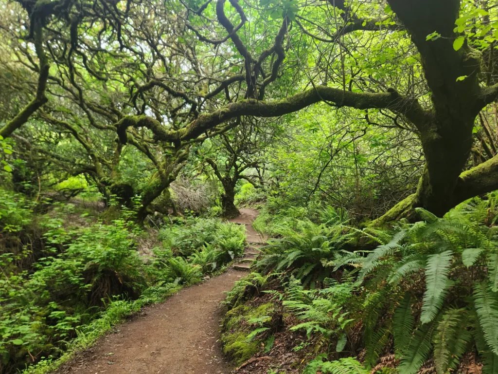
Hillside Trail
The Hillside Trail is a bit more challenging than the Main Trail. It runs parallel but climbs higher, so you get a new angle on the forest.
This narrow dirt path lets you wander through the middle layer of the redwood ecosystem, looking down at the forest floor and up at the canopy. It’s a different perspective, and honestly, a little more adventurous.

There are some wooden staircases and moderate inclines, so wear decent shoes—especially if it’s been raining and the path is slick.
From up here, you might spot birds like Steller’s jays and chickadees hanging out in the middle branches. The Hillside Trail reconnects with the Main Trail via several bridges, making it easy to mix and match your route.
Dipsea Trail and Beyond
The Dipsea Trail links Muir Woods to Stinson Beach. This one’s for folks who want a real workout—it climbs out of the redwoods and cuts through coastal scrub and grasslands.
The full Dipsea route is 7.4 miles one way and has some serious elevation changes. Many hikers pair it with the Ben Johnson Trail for a 4-mile loop back to Muir Woods.
From the higher sections, you get sweeping ocean views if the weather cooperates. Bring water, snacks, and solid hiking gear—this isn’t a stroll in the park.
Each June, the annual Dipsea Race (America’s oldest trail running event) follows this path. Want to keep going? Trails here connect with Mount Tamalpais State Park’s 50+ mile network, so you can really make a day of it.
Nature and Wildlife
Muir Woods lets you step into one of the last old-growth coastal redwood forests left. This place is packed with plants and animals that have figured out how to thrive in the shade and fog.
Flora in Muir Woods
The coastal redwoods (Sequoia sempervirens) dominate here, shooting up to 250 feet. These giants are usually 400 to 800 years old and create a kind of natural cathedral overhead. Unlike their inland cousins, the giant sequoias, coastal redwoods love the foggy air near the Pacific.

The forest floor is a whole world of its own. You’ll spot:
- Western sword ferns
- Redwood sorrel (those clover-looking leaves)
- Wild azaleas
- California bay laurel trees
- Big leaf maples
In winter and spring, mushrooms sprout from fallen logs. Redwood bark is thick and fibrous, which helps protect the trees from fire, and their roots spread out wide—interlocking with neighbors for support, instead of going deep.
Wildlife Spotting
Most animals in Muir Woods keep their distance, but if you’re patient, you might spot a few. Common mammals include:
- Black-tailed deer
- Western gray squirrels
- Chipmunks
- Raccoons
Birders can look for northern spotted owls, Steller’s jays, and woodpeckers in the branches. The creek running through the monument is home to salmon and steelhead trout during spawning season.

Early mornings are your best bet for seeing wildlife, when it’s quieter. Move slowly, keep your distance, and always stick to the trails—it’s better for you and the animals.
Conservation Efforts
Muir Woods became a National Monument in 1908 after President Theodore Roosevelt set it aside for protection. That move saved one of the last coastal redwood groves near San Francisco.
Park rangers run guided walks that dive into forest ecology and preservation. The National Park Service controls visitor numbers with a reservation system to keep the impact low.

Climate change is a new challenge for the redwoods. These trees rely on coastal fog for moisture, but that’s been fading in some spots. Scientists keep a close eye on forest health and how these ancient trees are handling the changes.
If you want to help, stay on marked trails, pack out your trash, and give wildlife plenty of space.
Visitor Facilities and Services
Muir Woods keeps amenities pretty simple—enough to make your visit comfortable, but nothing that takes away from the forest. Facilities are tucked away and designed to blend in, but they do the job for the thousands who visit each year.
Visitor Center Overview
The Visitor Center is your first stop near the main entrance. Friendly park rangers are there to answer questions and hand out trail maps.
Inside, you’ll find educational displays about redwoods, local wildlife, and the monument’s history. There’s a short orientation film looping throughout the day, which is actually worth a few minutes if you want some background.

Rangers offer scheduled talks outside the Visitor Center—quick 15-minute sessions on topics like redwood biology or conservation. Check the schedule when you arrive.
Luxury stays to cozy cottages await, all with instant booking. Find the best deals!
Browse Marin Stays
You can pick up maps and guides for purchase if you want more details for your hike.
Gift Shop and Café
The gift shop has a thoughtful mix of souvenirs, books, and educational stuff. Most of the merchandise focuses on redwoods, local ecology, or conservation—not your usual touristy fare.
Favorites include:
- Field guides to local plants and animals
- Redwood seedlings (ready for travel)
- National Park passport stamps
- Locally made crafts and art

The Muir Woods Café serves up simple meals and snacks with local, sustainable ingredients. You’ll usually find:
- Sandwiches and salads
- Seasonal soups
- Coffee and tea
- Grab-and-go snacks for hiking
Both spots are open daily from 9am to 5pm, though hours can shift with the seasons. Proceeds help fund park upkeep and education.
Restrooms and Amenities
Restrooms are at the main entrance and at Bohemian Grove, halfway through the main trail loop. They’re kept clean and include accessible options for visitors who need them.
Water fountains and bottle-filling stations sit near each restroom. Bring your own reusable bottle—bottled water isn’t sold here, which is great for cutting down on plastic.
Benches are scattered throughout the monument, blending in with the woods and offering a spot to catch your breath or just take it all in.

Don’t count on cell service in the monument. It’s pretty much a dead zone, so plan ahead if you need to stay in touch—maybe just enjoy the break?
First aid is available at the Visitor Center for minor scrapes. For bigger emergencies, staff can call in outside help fast.
Guided and Self-Guided Experiences
At Muir Woods, you can explore the redwoods two main ways: guided tours with naturalists or a self-guided walk at your own pace.
Highlights of the Guided Tour
Guided tours give you insights you might never discover solo. Rangers and certified guides share stories about redwood ecology, forest history, and conservation. They’ll point out hidden gems like fairy rings and explain how these giants “talk” underground—who knew?
Most tours last 90 minutes to 2 hours and stick to the main paths. Group sizes vary, from small 8-person groups to bigger tours of 20-25.
Check all available Muir Woods Tours here.
Guided tours offer:
- Expert knowledge on wildlife, plants, and forest ecology
- A structured experience with planned stops
- Chances to ask questions along the way
- Historical context about conservation and John Muir’s legacy
Some tours even bundle in trips to Sausalito or Wine Country for a full-day outing.
See our recommended Muir Woods Tours here
Self-Guided Walks
Going self-guided lets you set your own pace and follow your interests. The main path is flat, paved, and wheelchair accessible—so it’s open to everyone.
If you’re craving more adventure, side trails like Canopy View or Fern Creek offer a quieter, more challenging hike with some great views.

Why go self-guided?
- Flexibility to hang out at your favorite spots
- Solitude if you come early or late in the day
- All the time you want for photos
- Moments for personal reflection in the forest
Informative signs dot the main trails, offering tidbits on history and ecology. Many folks download the park’s audio tour app beforehand for extra context while wandering solo.
See our recommended Muir Woods Tours here
Picnicking and Nearby Activities
If you’re planning to visit Muir Woods, you can stretch your experience beyond the trails. The monument and nearby areas have designated picnic spots and plenty of outdoor activities to round out your day.
Picnic Spots and Rules
Picnicking is only allowed in the designated areas near the entrance. You’ll find wooden tables set among the trees—a pretty nice backdrop for lunch. These spots are first-come, first-served, so show up early, especially on weekends or holidays, if you want a table.

Keep in mind:
- No barbecues or open flames
- Pack out all your trash (no garbage service here)
- No alcohol allowed
- Secure your food to keep wildlife out
Midweek mornings or late afternoons are usually the best times for a picnic, with fewer crowds. Bring water, too—drinking fountains can be limited.
Nearby Muir Beach
Just three miles from Muir Woods, Muir Beach feels like a world apart. It’s a small, crescent-shaped stretch of golden sand with wide-open ocean views—really a nice change of pace after the redwoods.

You’ll find:
- Public parking (though spots fill up fast)
- Restrooms
- Picnic tables with ocean views
- Easy access to the Coastal Trail
If you’ve got a little time, swing by Muir Beach Overlook. It’s only a short drive and the views of the Pacific coastline are pretty spectacular. There are a few displays up there about local marine life and the area’s history—worth a quick read if that’s your thing.
Tides can shift quickly here, so check conditions before you think about swimming. Good news: dogs are welcome at the beach, unlike at Muir Woods where they’re not allowed.
Other Local Outdoor Activities
The area around Muir Woods is packed with outdoor options, all within a short drive.
Some favorites:
- Hiking: Hop on the Dipsea Trail for a challenging trek out to Stinson Beach.
- Mountain biking: Mount Tamalpais State Park has trails for every skill level.
- Horseback riding: You can book a guided ride at one of the local stables—great way to see the coastal hills.
- Birding: The wetlands at Muir Beach attract all sorts of birds, especially during migration. Bring binoculars if you have ’em.

Mount Tamalpais State Park is just minutes away, and the views from the 2,571-foot peak are unreal. The Mountain Theater puts on outdoor performances in the summer—worth checking out if you time it right.
Tennessee Valley, part of the Golden Gate National Recreation Area, is perfect for family-friendly hiking. You’ll get coastal views and probably spot some wildlife, too.
Exploring the Surrounding Area
Muir Woods sits in the middle of some seriously interesting places. The Bay Area has everything from quirky waterfront towns to world-class wine regions, and most of it’s a pretty easy drive.
Sausalito and Waterfront Attractions
Sausalito is just three miles from Muir Woods, so it’s an easy stop after wandering among the redwoods. This waterfront town treats you to views of San Francisco’s skyline and a main street lined with art galleries, little boutiques, and seafood spots where you can grab lunch with a view.

The Sausalito Boardwalk is perfect for a quick stroll. You can watch boats in the marina or check out the funky houseboats that give the town its charm.
For lunch, Barrel House Tavern or Scoma’s both serve up fresh seafood right on the water. If you’re into art, there are plenty of galleries along Bridgeway Avenue to poke around in.
Give yourself at least a couple of hours to explore Sausalito. Honestly, you could spend a whole day there if you don’t want to rush.
Day Trips to Wine Country: Napa and Sonoma
Wine country is about an hour north of Muir Woods. Sonoma is a bit closer and, honestly, feels more relaxed and less crowded than Napa.
- Sonoma Plaza – a historic town square full of shops and tasting rooms
- Family-run wineries like Gundlach Bundschu and Benziger
- More affordable tastings (usually $15-25)

- St. Helena’s Main Street for fancy shopping
- Big-name wineries like Robert Mondavi and Domaine Carneros
- Oxbow Public Market for local bites and crafts
Most wineries close by 5pm, so it’s smart to start your day early. Book tastings ahead if you can, especially at busy times—those spots fill up fast.
Other Nearby Destinations: Alcatraz and San Francisco Sights
San Francisco is just across the Golden Gate Bridge from Muir Woods. You can tour Alcatraz Island, but book your tickets well in advance—they disappear quickly.
Fisherman’s Wharf is packed with seafood joints and you can usually spot sea lions hanging out at Pier 39. Ghirardelli Square is nearby if you want some chocolate in a cool old building.

Chinatown and North Beach (Little Italy) are right next to each other. It’s fun to walk from one to the other—grab some dim sum, then wander over for coffee or cannoli.
If you’re after Golden Gate Bridge photos, check out Fort Point under the bridge or head to Baker Beach. Both make for classic shots.
Pacific Heights is full of gorgeous Victorian homes and old mansions. The “Painted Ladies” at Alamo Square? They’re as photogenic as you’ve heard.
Tips for a Memorable Visit
Muir Woods is best enjoyed with a little planning. A few practical tips can make your redwood adventure a lot smoother—and help you respect this unique place.
What to Bring and Wear
Pack layers. The redwood forest stays cool and damp all year, with temps usually somewhere between 40 and 70°F. Even in summer, you’ll want a light jacket or sweater.
Wear comfy shoes with good grip. Most paths are paved or boardwalk, but they can get slippery when wet.

Handy things to bring:
- Water bottle (there are refill stations)
- Snacks (not much food for sale onsite)
- Camera and spare battery
- Binoculars for spotting wildlife
- Small backpack
- Printed map (cell service is basically nonexistent)
A flashlight or headlamp comes in handy if you stay late—the thick canopy makes it darker earlier than you might expect.
Photography Recommendations
Shooting in Muir Woods is tricky—there’s a lot of contrast between bright patches and deep shadows. Early morning light is usually the prettiest, when sunbeams filter through the trees.
If you’ve got a tripod, bring it for those low-light shots. Some of the best photos come from looking up at the giant redwoods, or getting close to details like ferns and moss.

Try mixing it up:
- Frame a redwood trunk with nearby greenery
- Catch sunbeams cutting through the canopy
- Include a person in your shot to show just how massive the trees are
- Look for cool bark patterns
HDR mode can help balance the tough lighting. Just remember to stick to the paths—protecting the habitat matters more than any photo.
Sustainability and Visitor Etiquette
Stick to the marked trails—seriously, it matters. When people wander off, they trample the delicate roots of ancient redwoods and crush the smaller plants trying to make a living down there.
Try to keep voices down. The forest has this calm vibe, and a lot of folks come just to soak up the quiet. Loud chatter? It tends to scare off wildlife and kind of ruins the mood.

Take everything you bring with you when you leave. Sure, there are trash cans around, but having a small bag for your own waste makes a real difference. The forest isn’t a place for litter.
Resist the urge to touch or carve into the trees. Human oils can mess up the bark, and honestly, these giants take ages to heal. They’re not billboards or souvenirs.
If you can, hop on the shuttle instead of driving. Fewer cars means less pollution and less chaos in the parking lot. The park’s reservation system? It’s actually pretty helpful for keeping this place special for everyone down the road.
See available accommodations near Muir Woods.
Find available hotels and vacation homes instantly. No fees, best rates guaranteed!
Check Availability Now

Adrian Rosal Park Travel Guide – Accessibility, Amenities, Activities, and More!

Alto Bowl Preserve Travel Guide – Accessibility, Amenities, Activities, and More!

Bald Hill Preserve Travel Guide – Accessibility, Amenities, Activities, and More!

Baltimore Canyon Preserve Travel Guide – Accessibility, Amenities, Activities, and More!

Bayside Park Travel Guide – Accessibility, Amenities, Activities, and More!

Blithedale Summit Preserve Travel Guide – Accessibility, Amenities, Activities, and More!

Bothin Marsh Preserve Travel Guide – Accessibility, Amenities, Activities, and More!

Buck’s Landing Travel Guide – Accessibility, Amenities, Activities, and More!

Camino Alto Preserve Travel Guide – Accessibility, Amenities, Activities, and More!

Candy’s Park Travel Guide – Accessibility, Amenities, Activities, and More!

Cascade Canyon Preserve Travel Guide – Accessibility, Amenities, Activities, and More!

Charles F. McGlashan Pathway Travel Guide – Accessibility, Amenities, Activities, and More!

China Camp State Park Travel Guide – Accessibility, Amenities, Activities, and More!

Corte Madera Pathway Travel Guide – Accessibility, Amenities, Activities, and More!

Hal Brown Park Travel Guide – Accessibility, Amenities, Activities, and More!

Horse Hill Preserve Travel Guide – Accessibility, Amenities, Activities, and More!

King Mountain Preserve Travel Guide – Accessibility, Amenities, Activities, and More!

Lagoon Park Travel Guide – Accessibility, Amenities, Activities, and More!

Loma Alta Preserve Travel Guide – Accessibility, Amenities, Activities, and More!

Lucas Valley Park Travel Guide – Accessibility, Amenities, Activities, and More!

Lucas Valley Preserve Travel Guide – Accessibility, Amenities, Activities, and More!

McInnis Park Travel Guide – Accessibility, Amenities, Activities, and More!

McNears Beach Park Travel Guide – Accessibility, Amenities, Activities, and More!

Mill Valley-Sausalito Pathway Travel Guide – Accessibility, Amenities, Activities, and More!

Mount Tamalpais State Park Travel Guide – Accessibility, Amenities, Activities, and More!

Muir Woods National Monument Travel Guide – Accessibility, Amenities, Activities, and More!

Pueblo Park Travel Guide – Accessibility, Amenities, Activities, and More!

Ring Mountain Preserve Travel Guide – Accessibility, Amenities, Activities, and More!

San Pedro Mountain Preserve Travel Guide – Accessibility, Amenities, Activities, and More!

Santa Venetia Marsh Preserve Travel Guide – Accessibility, Amenities, Activities, and More!

Tennessee Valley Travel Guide – Accessibility, Amenities, Activities, and More!

Terra Linda/Sleepy Hollow Preserve Travel Guide – Accessibility, Amenities, Activities, and More!

White Hill Preserve Travel Guide – Accessibility, Amenities, Activities, and More!


Cities and Towns in Marin County

Things to Do in Marin County

Places to Stay in Marin County
